Lehtimäki
Appearance
You can help expand this article with text translated from the corresponding article in Finnish. (June 2023) Click [show] for important translation instructions.
|
Lehtimäki | |
|---|---|
Former municipality | |
| Lehtimäen kunta Lehtimäki kommun | |
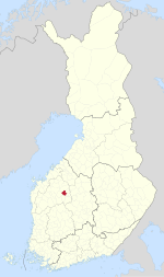
 Location of Lehtimäki in Finland | |
| Coordinates: 62°49′05″N 23°56′35″E / 62.81806°N 23.94306°E | |
| Country | Finland |
| Region | Southern Ostrobothnia |
| Sub-region | Kuusiokunnat sub-region |
| Charter | 1866 |
| Consolidated | 2009 |
| Area | |
| • Total | 288.8 km2 (111.5 sq mi) |
| • Land | 271.84 km2 (104.96 sq mi) |
| • Water | 16.96 km2 (6.55 sq mi) |
| Population (31 December 2008)[2] | |
| • Total | 1,849 |
| • Density | 6.4/km2 (17/sq mi) |
| Time zone | UTC+2 (EET) |
| • Summer (DST) | UTC+3 (EEST) |
Lehtimäki is a former municipality of Finland. It was consolidated to Alajärvi on 1 January 2009.
It is located in the province of Western Finland and is part of the Southern Ostrobothnia region. The municipality had a population of 1,850 (2006) and covered an area of 291.32 km² of which 18.88 km² is water. The population density was 7.2 inhabitants per km².
The municipality was unilingually Finnish.
References
[edit]- ^ "Area by municipality as of 1 January 2011" (PDF) (in Finnish and Swedish). Land Survey of Finland. Retrieved 9 March 2011.
- ^ "VÄESTÖTIETOJÄRJESTELMÄ REKISTERITILANNE 31.1.2012" (in Finnish and Swedish). Population Register Center of Finland. Archived from the original on 3 October 2013. Retrieved 11 February 2014.
External links
[edit]![]() Media related to Lehtimäki at Wikimedia Commons
Media related to Lehtimäki at Wikimedia Commons


